And after all those thunderstorms and Cumulonimbus, such as in summer, today the weather is totally different.
After yesterday's warm and sunny weather (max 15oC) the temperature right now is 6,9oC and it's raining! But the rain seems to be frozen and it looks like snow! In some areas the rain has turned into sleet and it's snowing above 700m on Hortiatis mountain next to Thessaloniki!!
However, tomorrow the weather will be sunny and it will be long till the next rainfalls...
Really strange weather we had this year...

Monday, 19 November 2007


Sunday, 18 November 2007
Summer clouds and thunderstorms in November! (photos)
And this is the video, showing lightnings from the thunderstorms yesterday.
The first lightnings are from the huge multicell towards East Macedonia and Thraki (Kavala, Serres, Rodopi etc), that also caused floods and many damages. And the rest of the video shows the thunderstorm, that was developed ~2:30 over Thermaikos with rainfalls and hail.

...and thunderstorms towards NW far away. 
Later, a huge and fascinating Cumulonimbus incus was getting closer from SE!

But unfortunately, it was dissolved into those Altocumulus clouds some hours later.

Bad weather all over Greece (photos)
As I have already written it's not usual to see lightnings and thunders during the months from November til March in North Greece.
However, yesterday thunderstorms and rainfalls were covering almost whole Greece.
The weather in Athens was really interesting yesterday. In the beggining of the day a large funnel cloud was whirling and many damages would have been caused if it had touched down! Photos like these are seen mainly in USA and it looks like a tornado!


The photos are taken by Kostas Vitsios
Later in the day, another thunderstorm was getting closer Athens with this fascinating wall cloud!

Photo taken by Maria Kavadia
So, two thunderstorms struck Athens with severe rainfalls and hail!
Similar phenomena were affecting other areas in Greece.
Also in North Greece!
More thunderstorms could be seen yesterday night around Thessaloniki. It started rumbling around 21:30 and I noticed many lightnings from NE to S! I was informed, that a huge multicell was covering an area from Halkidiki to Rumania! Although the thunderstorm wasn't getting closer, it was thundering for over ~5 hours!
But Thermaikos gulf made a thunderstorm by himself and at 2.30 the thunderstorm was giving severe rainfalls and loud rumbles! Everything ended after 30 minutes and the thunderstorm was turning to North.
Videos will be posted later
However, yesterday thunderstorms and rainfalls were covering almost whole Greece.
The weather in Athens was really interesting yesterday. In the beggining of the day a large funnel cloud was whirling and many damages would have been caused if it had touched down! Photos like these are seen mainly in USA and it looks like a tornado!


The photos are taken by Kostas Vitsios
Later in the day, another thunderstorm was getting closer Athens with this fascinating wall cloud!
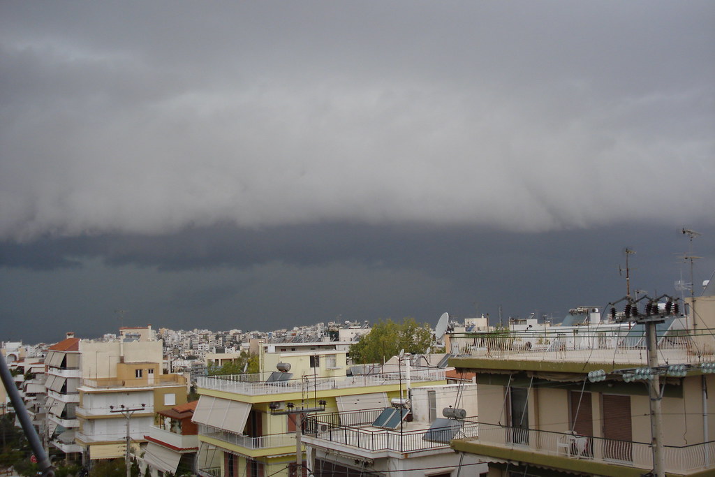
Photo taken by Maria Kavadia
So, two thunderstorms struck Athens with severe rainfalls and hail!
Similar phenomena were affecting other areas in Greece.
Also in North Greece!
More thunderstorms could be seen yesterday night around Thessaloniki. It started rumbling around 21:30 and I noticed many lightnings from NE to S! I was informed, that a huge multicell was covering an area from Halkidiki to Rumania! Although the thunderstorm wasn't getting closer, it was thundering for over ~5 hours!
But Thermaikos gulf made a thunderstorm by himself and at 2.30 the thunderstorm was giving severe rainfalls and loud rumbles! Everything ended after 30 minutes and the thunderstorm was turning to North.
Videos will be posted later
Friday, 16 November 2007
Thunderstorm near Thessaloniki right now!
The thunderstorms, that were covering the Ionian sea, managed to pass the mountain range of Pindos and now they are South of Thessaloniki.
Lightnings are seen and they few rumbles can be heard from thunders near Thessaloniki. It's been raining since 19.35, but although the thunderstorm seem to have an East direction the rain continues. Thunderstorms are also forecasted till later at night...
It should be noticed, that thunderstorms are seldom seen in North Greece during November and winter...

Saturday, 10 November 2007
The first snow flakes in Thessaloniki & severe wind gusts! (photos)
The cold air over Europe finally came towards Greece this morning. The North wind became stronger and the min temperature was 6oC at 10:05. Snowflakes managed to appear before the strenghtening of the North wind, that always clears up the sky, here in North Greece and some snowfalls affected most of the mountains in North and Central Greece. You can watch some snowflakes on the video below...
(Unfortunately, the quality is too bad...)
It didn't last for a long time and the clouds quickly disappeared, because of the really severe wind gusts, that continue untill now!
The airport reported max wind gust 111km/h* (!) and the average wind speed ~60-85km/h*! Many trees have fallen down, damages are also caused and Thermaikos looks like Atlantic Ocean!!
The max temperature was 10oC at 13:00, but it began to decrease immediately and it's 7oC outside now!
Some photos


###
*7Beaufort=~15m/s=~55km/h
8B=~19m/s=~68km/h
9B=~22m/s=~80km/h
10B=~26m/s=~88km/h
11B=~29m/s=~110km/h
Subscribe to:
Posts (Atom)