Thursday 27 December 2007

Cold weather and rime just before Christmas in Norway (photos)

After many years of not going to Norway during winter, my wish to return came true! I will stay in Arendal, Aust Agder till 4 January 2008 and I hope I am going to see some snow...although I don't think so... It has already snowed in Thessaloniki, whereas in South Norway they are still waiting!

I arrived on Friday night in Kristiansand, Vest Agder, where the temperature was really low. But it had already been cold in South Norway during last week with temperatures being around -11oC...-4oC during the day! So, while driving to Arendal (~65km East of Kristiansand) the max temperature I met was -3oC and the min -11,5oC*, while some fog-clouds were appearing in the sky!
But low temperature was not the only interesting during last week, when I was not in Norway. The weather was also dizzy and dense fog had been covering many areas in South Norway for many hours everyday. So, thick rime was formed and covered all surfaces, just as everything looks like after a snowfall! My grandmother described to me, the way the sun was shining through the fog one day, something that made the tiny ice crystals glow and she said that it was like watching small diamonds falling down from the sky! I’m almost sure that an optical phenomenon like parhelia must have been seen. Something else that was formed because of the really low temperatures was thick ice on the sea surface!
When I finally arrived in Arendal, the temperature was as low as -7,5oC and the sky was clear. Here are some photos I took showing the rime, just after my arrival!
Everything was frost.
101_7762

The little neighborhood, where I stay every time I come to Norway 
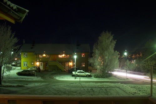
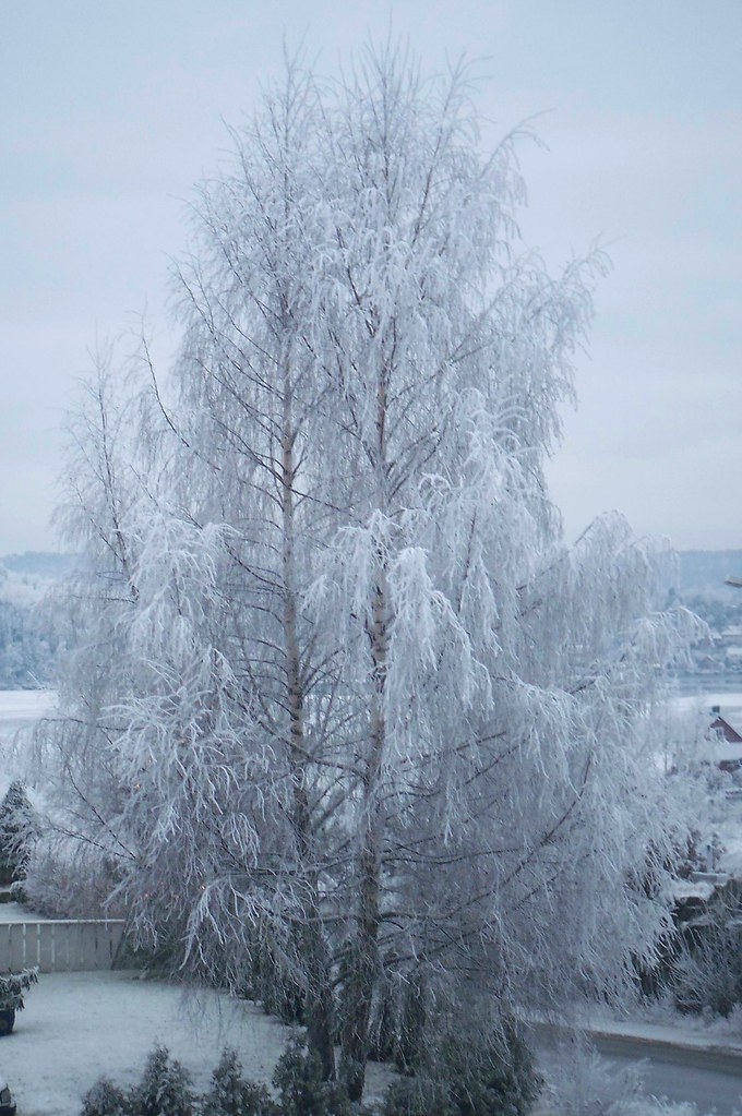
101_7771


A frozen tree
101_7766


In the garden
101_7779  101_7777

The ground, covered of rime


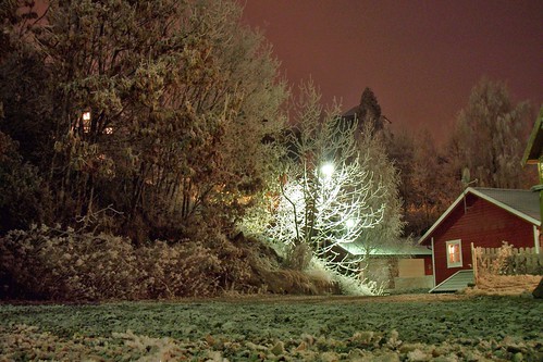
A new, white day has just started. Everything looks like it had been snowing!

101_7810


The island Tromøy to the right and the bridge, Tromøybrua can also be seen
101_7831


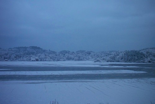
In Arendal centre the sea is frozen and some birds are just walking on the ice 101_7834 
 
Rime seen on the grass 

101_7843 

White houses and trees


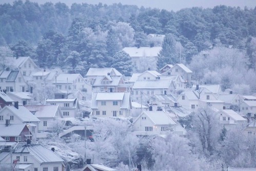
The small island, Hisøy...
101_7848


...and Tromøy
101_7850 


Some icicles back of some trees
101_7861

Beautiful rime formations


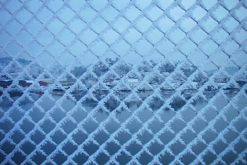
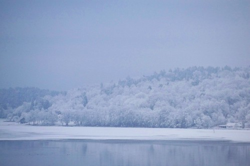
The sea covered by ice with Tromøy in the background
 
101_7871 101_7878
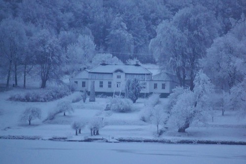
Really fascinating forest on Tromøy


Another close-up rime formation
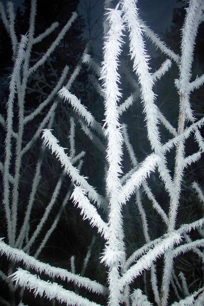

Everything is white


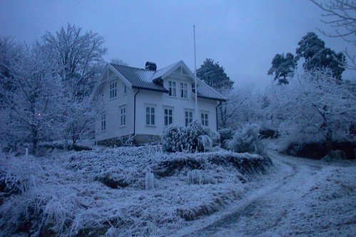
But the things got worse during Saturday. When it was getting darker, instead of getting colder the temperature continued to rise and finally reached +0,3 at midnight with some fog covering the area! So...all these fascinating landscapes are gone now and the ice has melt...
The temperature finally reached +2,7oC Sunday 05:55 and when I woke up at ~11:00 the sun had just risen up and I noticed that the temperature had fallen to ~1oC...I supposed, that the temperature felt because the sky was cloudless now... However, even during afternoon, when the sun was shining the temperature was still falling above 0oC, something that made everything wet, frost and the streets quite dangerous. The temperature stopped at -3,4oC at 22.50 and frost-smokes (as they say in Norway) appeared over many areas, because of the cold surfaces.
PHOTO

Christmas day for Norway is 24/12 and Monday's min was -3,1oC at 00:30, but the temperature soon started to rise again till the max was marked at 17:40 with 5oC. Christmas was windy with some drizzles. Nothing interesting...

So, Tuesday 25/12 had also some strange temperature changes. At midnight the temperature was +3,3oC, but a temperature drop was followed till 05:55 with -1oC. So, began a temperature-rise...again and I noticed, that it started raining at 09:35 with the temperature at +0,2oC!
It was snowing last Saturday in Thessaloniki with +3oC and it's raining in Norway with just +0,2oC!?*
And finally, the max of the day was +5,2oC at 21:30…

Wednesday started with cloudy weather and +4,1oC at midnight. So, the min followed at 04:50, which was +0,4oC, but the temperature after that didn’t rise that much, maybe because of the clear sky and the temperature was around +1oC the whole afternoon. But the temperature began to irritate me again by rising to +4,7oC at 23:10, while the sky was getting mostly cloudy and this was also the max of the day…

And I thought the max temperature is during daylight…
**Well, I can refer some differences I noticed between the weather in Norway and Greece.
Although the temperature in Norway were really low and even -11oC, I can't say, that I was freezing. I felt those -11oC in Norway like -1oC in Greece! When it's cold in Greece, it's awful cold, even when the temperature is not under 0oC! I feel my hands, my ears hurt and my nose really cold, which always gets red and when it's windy it's much worse! The wind is just getting through your clothes, something that didn't happen in Norway. I could easily keep myself warm only by wearing a coat!

Something else I noticed in Norway is the combination between the temperature and the snowfalls. Last Saturday Thessaloniki, Greece was experiencing severe snowfalls with temperatures during night and day above 0oC! The min was +0,7oC and the max +3,4oC! The snow didn't cover the ground, but it was snowing! It started raining only in South Thessaloniki, when the temperature was as high as +4oC and the humidity as high as 97%, whereas it was snowing at the same time in north Thessaloniki with +2oC! It has snowed in Greece many times, while the temperature was above 0oC!
However, I have noticed that it hardly snows in Norway even if the temperature is 0oC or even just below 0oC... For example, on Tuesday morning the temperature was +0,2oC and I was surprised to see, that it was raining! I remember when I was younger, the same thing happening....
I can't explain why this is happening, but I suppose it has to do with the temperature in higher altitudes.... But logically, the temperature should be lower in Norway and not in Greece, right?


Well, I hope I didn't was tiring for you to read all this.

I will write again, if............I see any snow, or anything else interesting....

I wish you happy holidays and a happy new year!

Thursday 20 December 2007

Snowy Greek landscapes (photos)

And after the snowfalls on Saturday afternoon, I decided in the evening to stay at my grandparents' house for the weekend. The live in Diavata, Nea Ionia, a Northern part of Thessaloniki. The sky was clear and only some clouds appeared during night of Sunday. And suddenly, I opened my eyes at 7:30 and was so lucky to notice, that a beautiful sunrise was going to follow, as the temperature was as low as -2oC!
101_7645 101_7655 

101_7654
After all those snowfalls, I wanted so much to go to "my village" (as we say here in Greece), Petroto. Petroto is a small village North of Thessaloniki, in the countryside, where the temperature is lower and I thought, that the snow wouldn't have melt. And I was right. The snow was still covering trees and mountains, but it started melting there, too, as the temperature was higher than 0oC...

101_7680 101_7683 101_7701
101_7706 101_7709
I suppose, that the snow amount had been around 6-7cm, but some of it had already melted. The clouds started covering the sky, but because of the Cirrostratus-clouds the sun could be seen through them.

101_7715
And so, at ~02.30 Monday, it startes snowing again back in Diavata! The temperature was around 1oC, so cars and parks were being covered by the snow.

However, it wasn't snowing in all areas of Thessaloniki. For example, in Kalamaria it was raining mixed with some wet snowflakes with 3oC and 97% humidity! It continued to snow in the morning, but the temperature was rising and it finally stopped at noon...

Saturday 15 December 2007

Severe snowfalls after 2 years in Northern Greece! (photos)

At last! After 2 years of dry and boring weather, I'm watching snowflakes again! I had forgotten how it was to see snowflakes flying around! The weather is back to normal again.

The first snowflakes appeared Friday ~22.30 in the city of Thessaloniki with 3oC!


But as the temperatute was falling and the snowfall was getting more severe during the night, snow started covering trees, parks, but unfortunately not the streets...
101_7563

Early today the temperature was around 0,5oC, but soon started to rise, so the snow began to melt...
This photo is taken in the center of Thessaloniki early today, but not by me.


However, snowfalls were getting again even more severe at noon, but the streets just became wet...
101_7583
That does not make me sad at all, because the winter has just started and a Christmas-atmosphere was made! I am even more happy, especially when I see, that it hasn't snowed at all in areas of Northern Europe, such as South Norway!
The snow amount was only 1cm in the center in Thessaloniki, but in other towns in Northern Greece the snow was much more... For example, in Veria 10cm, in Kilkis 15-20cm, in Katerini 15cm, in Xanthi 10cm...

You can watch a video of the snowfalls here:


So yes, that's a normal start for winter, cause last winter was the worse! After the October (2006) floods, November started dry without rain and whole winter continued with droughts without snowflakes at all and only few days with rain... In contrast with Northern Europe and especially Southern Norway, where the amount of snow in February 2007 was over 4 meters!!! Neither winter, nor spring was rainy and so came summer, with even worse weather! Dry weather and 3 heatwaves with temperatures over 40oC, that lasted for days additionally, whereas Northern Europe was experiencing rainfalls and floods!!! The worst summer for years, but fortunately after the rainy days in October and November the weather came back to normal and there are hopes and many estimates, that the coming winter will be really cold and full of snowfalls and why not, a second 1988 or 2001 for Thessaloniki?

Thursday 13 December 2007

Northern Greece, ready for severe snowfalls!!!

At last severe snowfalls will appear in Northern Greece after 2 years of drought!!!
Specifically, on Friday morning snow will start falling in Eastern Greece and later in the day snowfalls will cover Northern and Central Greece, also areas near the coastline... However, even one day before the arrival of the cold-wave, nothing is sure about how the weather will go on... Will the temperature in areas, which are next to the sea, be low enough? Will the precipitation be enough, so that the snow will cover the ground? How long will the snowfalls last? Will rainfalls melt the snow?
Unfortunately, nothing is sure yet, and I hope in severe snowfalls in North Greece and Thessaloniki, because we really deserve it after 2 years of boring weather and drought... I personally, haven't seen a snowflake for these 2 years at all.
As you can understand I will continue with the WebcamsInNorway, when the whole thing is over...
You can read an interesting view about the severe snowfalls by Alan Reppert from AccuWeather here:
http://www.accuweather.com/news-blogs.asp?partner=accuweather&traveler=0&blog=reppert&date=2007-12-11_23:35&month=12">

Snow In Many Spots
Tuesday, December 11, 2007
Snow over most of Southeastern Europe, and that might even include seeing some snow in cities like Bucharest, Belgrade, Budapest and Sofia. But some of the more impressive locations that could see snow include near Istanbul, and into much of Greece. All I can say is this is quite an impressive cold wave, and the heart of this cold is coming in from Russia, the first major push of the year. But, how much snow can we see?

It really looks like most of the uncommon locations to see snow will be around only seeing some light snowfall, maybe a cm, but most of those locations will see just some light flurries mixing in. The center of the storm will be pushing well into parts of Southeastern Europe, meaning that this cold air will be quite an impressive blast. This moves in from near Scandinavia and just goes south through the day Wednesday and gets into central parts of Southeastern Europe near northern Greece early on Friday. But this cold shot will only be temporary as the true heart of the cold gets pushed off to the east for late Saturday and into Sunday. It truly is quite impressive -- this cold shot -- as it could help to bring temperatures well below normal for the month from just the next few days alone. But how much snow will we see?

Yes, it's very difficult to say this area will see this much and this will see this much, so it's best to check AccuWeather.com for that info for each and every one of your locations. But generally speaking, through early Sunday, there might be around 10 cms in some of the higher elevations of the eastern Alps and to the south over some mountains above roughly 700-1,000 meters. I do think there could be an area that sees some heavy snowfall, especially near the track of the upper-level low. There may be some locations that see around 2cms in some of the highest elevations, so enjoy this snow! Farther to the south and also at lower elevations, there will be snow to elevations of even around 100 meters or less, so watch for this even near the coastline. There could be some snow mixing in with these showers just near the coastline, and this might be one of the only chances we see of having snow for the year in these spots. But do enjoy the snow, it will surely be good and very nice to see this cold to Christmas. Meanwhile, these mild temperatures are over Western Europe with a strong ridge of high pressure over the area.

Friday 7 December 2007

Webcams in Norway (Part 1)

The following link is a really interesting site, that includes a lot of webcameras from Norway! You can watch in real time a list of webcams, which are placed in towns, mountains, harbours, ski slopes and in other many areas!


http://www.webcamsinnorway.com/webcams.php

Let's see some of the webcams by selecting regions on the top of the site.
First region is Akershus in SE Norway. Not many cameras to choose, but these are quite interesting.

Drøbaksundet

and
Vøyenenga; Kirkerudbakken ski slope with snow


Next region in alphabetical order is Aust Agder. Aust Agder is in South Norway. Sunny weather there as you can see...
A nice town, where I travel every year (I'm 50/50 Norwegian/Greek), is Arendal!
This webcam shows the "Kulturhuset" in the centre of Arendal.
Kulturhuset

Some other nice webcams from the Agderposten.no (local newspaper).
Centre of Arendal


This webcam shows the small island Tromøy,

the even smaller island Hisøy

and the smallest of all, Merdø

The lighthouse "Lille Torungen" is also depicted in this webcam.

http://www.agderposten.no/apps/pbcs.dll/section?category=webcam

A town near Arendal is Grimstad.

Grimstad - Groosefjorden

Many webcams are also located on Hovden mountain, but they cannot be shown throug the site WebcamsInNorway.


Next region is Buskerud in SE Norway. Cloudy weather there now.
Bragernes

Drammen - harbour

Geilo mountain - ski slope


Kongsberg - Nybrua. Floods were caused by severe rainfalls around that river in July.


Finmark, the northest region of Norway! It's been snowing for weeks there, but the last 2 days the weather got warmer and snow has started to melt...But snowfalls are forecasted again for the next days, so it's worth to wathch these webcams after Monday.
Kirkenes (live! http://193.69.140.40/view/index.shtml )

Vadsø


Hedmark, SE Norway. Cloudy and snow covering the mountains.
Hamar - airport

Hamar - Vangsåsen


Hordaland, West Norway. Nice weather in most areas, and partly cloudy.
Bergen


Odda

Finse; railway station


Møre og Romsdal, West Norway. Rainy weather.
Kristiansund

Skei - ski slope